Maps
 07 December 2009
 I love me some maps, let's get that out of the way right now. Growing up as a child in Southern California I learned that you never, ever get in the car without a Thomas Guide in the back seat. I moved from OC to SD to The Bay blissfully unaware that those venerable brothers didn't offer maps for every part of the country. These maps had no equal; why wouldn't they be everywhere?
Imagine my surprise when I moved to Ohio in the summer of 2002 and drove straight to the Target for a Thomas Guide, only to find none. It was like someone scrambling all the channels on my television and then depriving me of a listing. I did find a crappy Rand McNally map that was the closest approximation. It failed however when I nearly got into an accident because it didn't have one-way streets marked as such, not to mention it barely covered all of Franklin county which is only slightly less excusable. And yes, Rand McNally had purchased Thomas Bros. in 1999, so there's that.
But this is 2009! As much as I will lament the loss of the Thomas Guide (called "the bible" while in the car, because it was often the source of salvation), I now bask in the glory of what is essentially a billion Thomas Guides in my pocket.
Yes, Google Maps (and others, but come on—Google led the charge and I bet you use it) has done a lot to help the hapless (as well as those teeming with hap) find their way, and with panache. First we got maps. Then satellite view. Then freeway traffic. Then street view. And now we have traffic for major streets (in major cities). All of these have brilliantly added features that are both useful and well-designed as we begin to realize the power of connected maps, especially on our mobile devices.
The Maps app on my iPhone which integrates with the Los Angeles public transit system (yes, we do have one) is singularly one of the best experiences I've ever had on a mobile device. Ever. The ease and beauty with which you can get bus and rail times, directions and transfers, and track your progress along the way is nothing short of navigation nirvana, even when the actual experience of riding transit isn't always so. The app even calculates your distance to the bus stop and tells you what time to leave your house to make it on time. Fucking awesome.
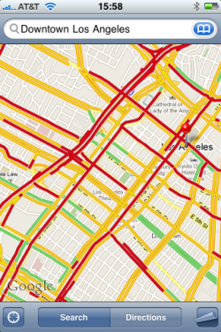
My only complaint at the moment has to do with the new street-level traffic. While it's a wonderful feature that many of us (especially those in the oft-gridlocked Los Angeles metro) are glad to see, when you have a billion streets that all qualify as "major" and are thus color-coded, you get something that looks like this:
Can you tell me where the 10 freeway runs? What about Pico or Figueroa? Yeah, me neither. So how about we fix this by superimposing the street names on top of the roads and traffic colors? I know my city pretty well, but that's just ridiculous.
But I digress…this is but a small complaint in the history of great navigational aids. As I said before, I love me some maps. And things are about to get better. Just as Google raised the bar (and then proceeded to raise it a few more times before anybody caught up), it appears Apple is getting ready for their own vault. Their hands have been chalked, they're gripping the pole, and they're about to make an attempt.
Whether they succeed or fail isn't as important as the fact they're taking a shot at it. Apple is taking a gigantic ball of awesome smothered in awesome sauce and topped with awesome and saying "nah, we can do better." God bless them for that, because we are all about to benefit.
Imagine what life would be like if everyone aspired to such heights…


Reader Comments (1)
Yes!!! I totally agree!! Drives me crazy! Should we start a petition?